

Dig deep into the proposals that will determine the future of the Chehalis Basin
What is the Aquatic Species Restoration Plan?
The Aquatic Species Restoration Plan (ASRP) is an ambitious proposal to restore the Chehalis Basin’s invaluable habitat and protect critical aquatic ecosystems from the existential threats of climate change. A key component of the Chehalis Basin Strategy, the ASRP is our best chance to combat the Chehalis’ declining salmonid populations and to prevent spring-run Chinook, a critical food source for Southern Resident orcas, from going extinct by the end of this century.
The ASRP provides a detailed, science-based roadmap for restoring habitat and protecting intact ecosystems of aquatic species along the rivers and streams of the Chehalis Basin. It is a complex and comprehensive analysis of necessary actions across the ten ecological regions that comprise the Chehalis Basin, Washington’s second largest watershed. And if implemented, the ASRP would be one of the largest watershed-scale restoration project ever completed in Washington.
The goals of the ASRP are threefold:
Restore communities: By investing in the healthy riparian forests and floodplains that are critical for salmon and other species, the ASRP is a major investment in the natural systems that sustain our economy.
Reconnect the flow: To ensure a resilient future for salmon in the face of climate change, we need to invest in the restoration of healthier aquatic ecosystems. The ASRP will enhance the function of aquatic ecosystems across the basin by strategically restoring the natural processes of these dynamic environments.
Reinvigorate rural communities: Without thriving natural resources, the local businesses at the core of the Chehalis Basin’s economy cannot thrive. The ASRP is a smart, strategic investment in the restoration and protection of the key lands and waters that are the engine of the basin’s economy.
There are three different scenarios proposed in the ASRP, which vary in extent of restoration implementation and associated costs. The Chehalis Basin Board will determine which scenario is recommended to the Governor for implementation. To learn more about each scenario of the ASRP, click here.

What is the genesis and purpose of the dam and why was the Upper Chehalis River chosen as the site for the dam?

Building a flood control dam in the Upper Chehalis Basin has been debated going back more than 20 years. The current proposal, now in the environmental review phase, gained traction following the catastrophic flood of 2007, which inundated the cities of Chehalis and Centralia and surrounding properties as well as submerged and closed I-5 for five days.
According to the project sponsor, Chehalis River Basin Flood Control Zone District (FCZD) the purpose of the dam is to “reduce damage from Pe Ell to Centralia from periodic flooding triggered by rainfall in the Willapa Hills. The facility is not intended to address flooding in all parts of the Chehalis Basin.”
The chosen site for the dam is based in large part on data indicating the Upper Chehalis River contributed on average 66% of flood waters in the Upper Basin in the top 10 historic floods. The source of water causing severe flooding in the Basin is “almost always” atmospheric rivers.
Notably, a 2003 report on flood damage reduction options for the Chehalis Basin by the U.S. Army Corps of Engineers explored five potential sites for flood control dams in the Upper Basin, including two sites on the Upper Chehalis River, and concluded “all five features were determined to be economically infeasible.”

How much would the dam cost?
The cost of the dam could top $1 billion dollars. According to a September 2018 budget report from the Office of Chehalis Basin, the dam would cost $628 million for permitting, design, engineering, mitigation and construction. A 2014 study of 245 dams in 65 countries, however, shows an average cost overrun of 96% for dam building.
The dam is being built for possible expansion in the future which will add to its cost. “The proposed flood retention facility is considered to be expandable because it would be built with a foundation and hydraulic structure extents capable of supporting the future construction of a larger structure and reservoir that could expand the water storage from 65,000 acre-feet to up to 130,000 acre-feet.”
How would the dam work?
The proposed dam would only store floodwater during major floods and then slowly release water over a period of up to about one month once the storm has passed. The temporary reservoir created by the dam, however, would back up and submerge more than six miles of the river corridor above the dam site.
According to the project proposal “a major flood in the Basin (an event with greater than 38,800 cubic feet per second at the Grand Mound gage) has a 15% probability of occurring in any given year (an approximate 7-year recurrence interval).”
The dam would not produce hydropower, would not produce supplemental water supplies for downstream farmlands and would not provide for recreation, as many dams do.
What are the causes of severe flooding in the Basin?
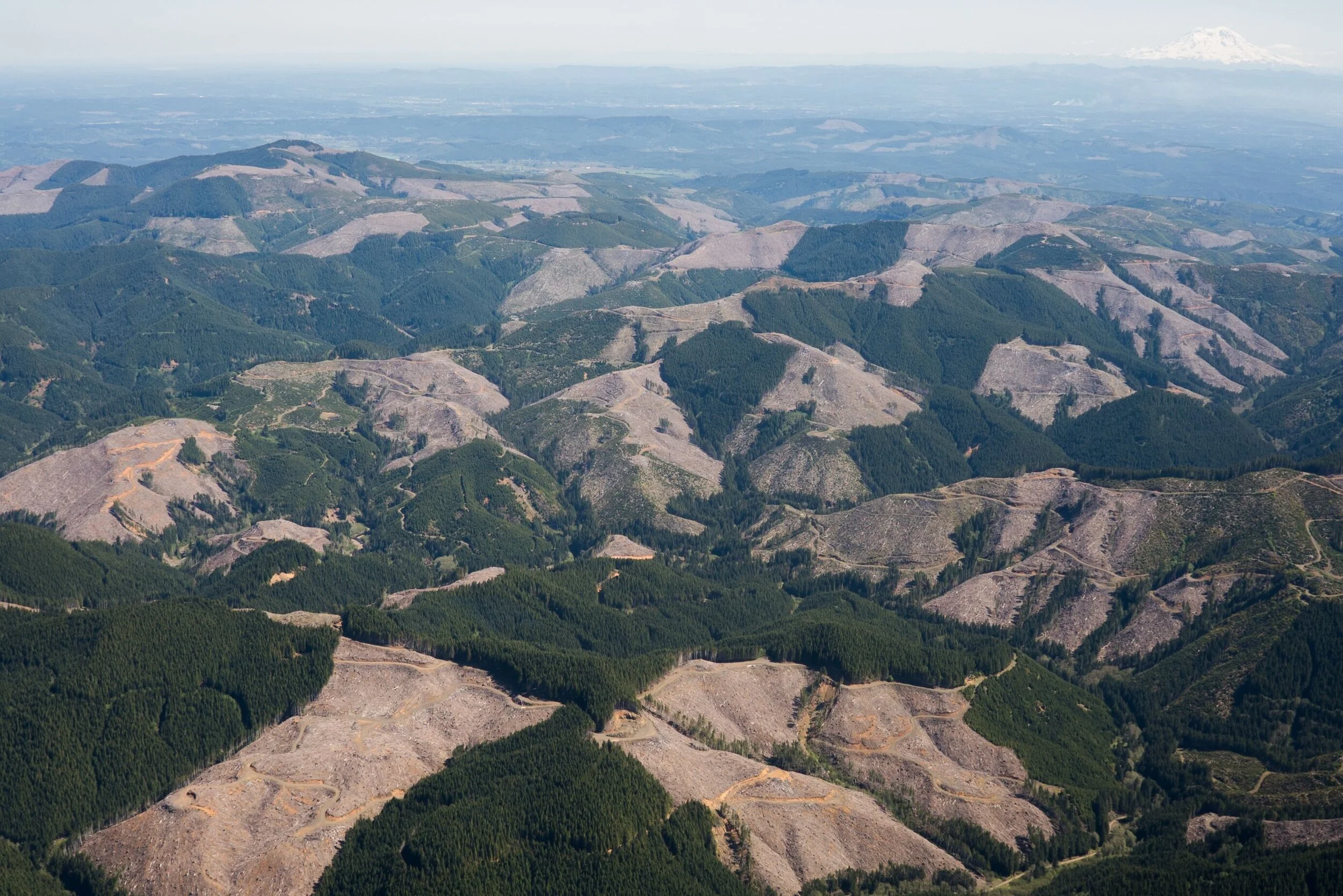
Atmospheric rivers coming off the Pacific Ocean are the source of severe floodwaters, but 150 years of human industry and development has diminished fish and wildlife habitat and dramatically altered how the Basin handles those periodic torrents.
Historically the river meandered across a floodplain with many natural features acting together to keep flooding in check. Side channels and wetlands spread floodwaters across the land while old growth forests absorbed and slowly drained rain and melting snow into the river. Oxbows, logjams and other natural structures formed the many and varied habitats along the banks and in the river channel where salmon and other aquatic species flourished.
Today, due to past logging and development, rain water finds its way much more rapidly into a constricted river system prone to landslides that largely lacks the relief valve of natural storage. The result is lost habitat and more severe flooding and flood damage. A Seattle Times news story following the 2007 flood described it this way:
“In one large clear-cut alone, nearly a dozen slides emptied into a creek. In some areas, log jams may have acted like small dams, temporarily holding back water until they toppled over or breached. Some upriver communities got slammed with the mess. Then the floodwater moved on, all the way to the cities of Chehalis and Centralia and the development in the floodplain along I-5. . .
While individual filling projects might not appear to have an impact, the cumulative effect of repeated development in a floodplain can mean big trouble, the experts argue. It’s like putting bricks in a bathtub. One brick displaces a little water. But a lot of bricks can force the tub to overflow.”
Habitat restoration actions can help reduce flood damage while improving conditions for fish and wildlife. In many parts of the Basin that don’t stand to benefit from the dam, restoration of natural floodplain functions is a cost-effective option to reduce flood damage.

How could the dam affect recovery of Southern Resident orcas?
The reasons for the decline of Orcas are complex and varied, but come down to three major problems that are interrelated and compound each other.
Noise and disturbance from vessel traffic make it harder for the whales to find and catch already scarce salmon.
Too much toxic pollution in the waters of Puget Sound builds up in Orcas’ fatty tissues which can weaken their immune systems, harm their reproductive health and make them more vulnerable to infection and disease, including cancer.
The decline of Chinook salmon runs, which make up the bulk of the diet for Southern Resident Orcas, means they aren’t getting enough to eat.
The main link between the dam and orca recovery comes down to how the dam would affect Chinook salmon. Spring Chinook in particular are important for Southern Resident orcas for the same reason as Columbia Spring Chinook in that their migration timing comes at a critical feeding time for this population. Southern resident orcas typically travel along the Washington and Oregon coasts in Spring to hunt for Spring Chinook which are especially rich in fat and have the highest caloric value of all salmon species and runs.
What is the dam’s potential impact on wild salmon and steelhead?
While detailed impacts are currently being studied through the environmental review process, construction and operation of the dam would likely have a major impact on salmon and other fish and wildlife. Reporting from a September 28, 2018 article in the Centralia Chronicle, describes the impact to Chinook Salmon as follows:
“Larry Lestelle, a consulting biologist to the Quinault (Nation) said the Chinook salmon that spawn upstream of the dam all spawn within the six-mile footprint of the reservoir that would be created during flood events. Salmon eggs depend on flowing water to bring them oxygen, meaning that all eggs upstream of the dam would be killed in years the reservoir is created. “Of all the salmon runs in the Chehalis system, spring Chinook are the ones that are in the toughest shape,” (Lestelle) said. “One of the strongholds historically was in the Upper Chehalis upstream of Pe Ell. Today, the run is much reduced ... If a dam was to be built in that area, it would seal the fate of that remnant run that’s still in the Chehalis.”
Both Spring and Fall Chinook spawn in September and early October. The big storms that would trigger the dam into operation happen typically start in November. Now imagine if the dam were activated each winter for several years running, a scenario that is more likely under climate change.

What is the dam’s potential impact on wildlife populations?
Infrastructure such as dams/retention facilities can have both immediate and long-term impacts on terrestrial and semiaquatic wildlife and their associated habitat. Initially, construction can have adverse impacts on human sensitive species such as elk, cougar, and bear. These species’ natural avoidance behavior can cause them to avoid the construction site, by dispersing away from the area. In addition, the dam/retention facility will result in direct habitat loss for certain flora and fauna in the area. Furthermore, areas of water retention will experience extreme changes to landcover type, further altering the existing ecosystem structure.
Long-term impacts of the dam/retention facility on terrestrial species include fragmentation, limiting access to and movement through riparian corridors, and increasing slope around the dam/retention facility, which can hinder some wildlife’s ability to navigate around the structure. An ongoing mapping process of the coastal Washington region for wildlife habitat connectivity suggests that the proposed dam/retention facility footprint exists within a key “natural” linkage, which connects protected and natural areas in the region for keystone species such as cougars, fishers, and mountain beavers. While the dam/retention facility does not completely block access to these “natural” corridors, it may force animals to the edges of the corridors, obstructing the current riparian corridor.

Which communities in the Basin would benefit, or not, given the stated purpose of the dam?
Residents, businesses and property owners from the town of Pe Ell to the cities of Centralia and Chehalis along the Upper Chehalis River would be the primary beneficiaries of the flood damage reduction goals of the dam. Construction of the dam could also encourage new commercial and other development in the floodplain in Centralia and Chehalis and in that case developers and other business interests would profit from the dam.
Many other communities in the Basin stand to share little, or not at all, in the stated benefits of the dam because they are located outside the area where the dam aims to reduce flood peaks. Those communities include Aberdeen, Hoquiam, Elma and Montesano in the Lower Basin as well as cities, towns and properties in the valleys of major tributaries of the Chehalis River such as the Satsop, Wynoochee, Newaukum and Humptulips rivers.
What are alternatives to the dam to both reduce flood damage and restore aquatic species?
By law, the upcoming Draft Environmental Impact Statements are required to provide alternatives to the dam. Addressing the flooding challenges in the Basin without building a dam would likely rely on many and varied actions such as restoring natural floodplain functions, moving people out of harm’s way and keeping them out of danger in the first place.
Many actions, such as forest and wetlands restoration, installing engineered logjams and building other structures to restore the complexity of river channels and banks, would also improve conditions for salmon and other aquatic species. Additional actions could include voluntary property buyouts and easements, improved land use practices, and flood proofing measures such as building walls and raised platforms to protect specific structures and provide refuge for people and livestock.